Hurricane Lee Updates

Updated: Thursday 9am Eastern Time

Hurricane Lee Wind Speeds

The above image from NOAA is the prediction for wind speeds of Hurricane Lee. Wind speeds of Hurricane force of 74 to 110 mph. The wind spped is expected to change to 39 to 73 mph after crossing into Nova Scotia, Canada on late Saturday.

Key Notes

There is the potential for life-threatening storm surge flooding in portions of southeastern Massachusetts, including Cape Cod and Nantucket, late Friday and Saturday, where a Storm Surge Watch is in effect.

Hurricane conditions and coastal flooding are possible in portions of eastern Maine, southern New Brunswick, and western Nova Scotia on Saturday, and a Hurricane Watch is in effect for that area. Heavy rainfall in these areas may produce localized urban and small stream flooding from Friday night into Saturday night. Tropical storm conditions are possible elsewhere across New England and Atlantic Canada within the Tropical Storm Watch areas
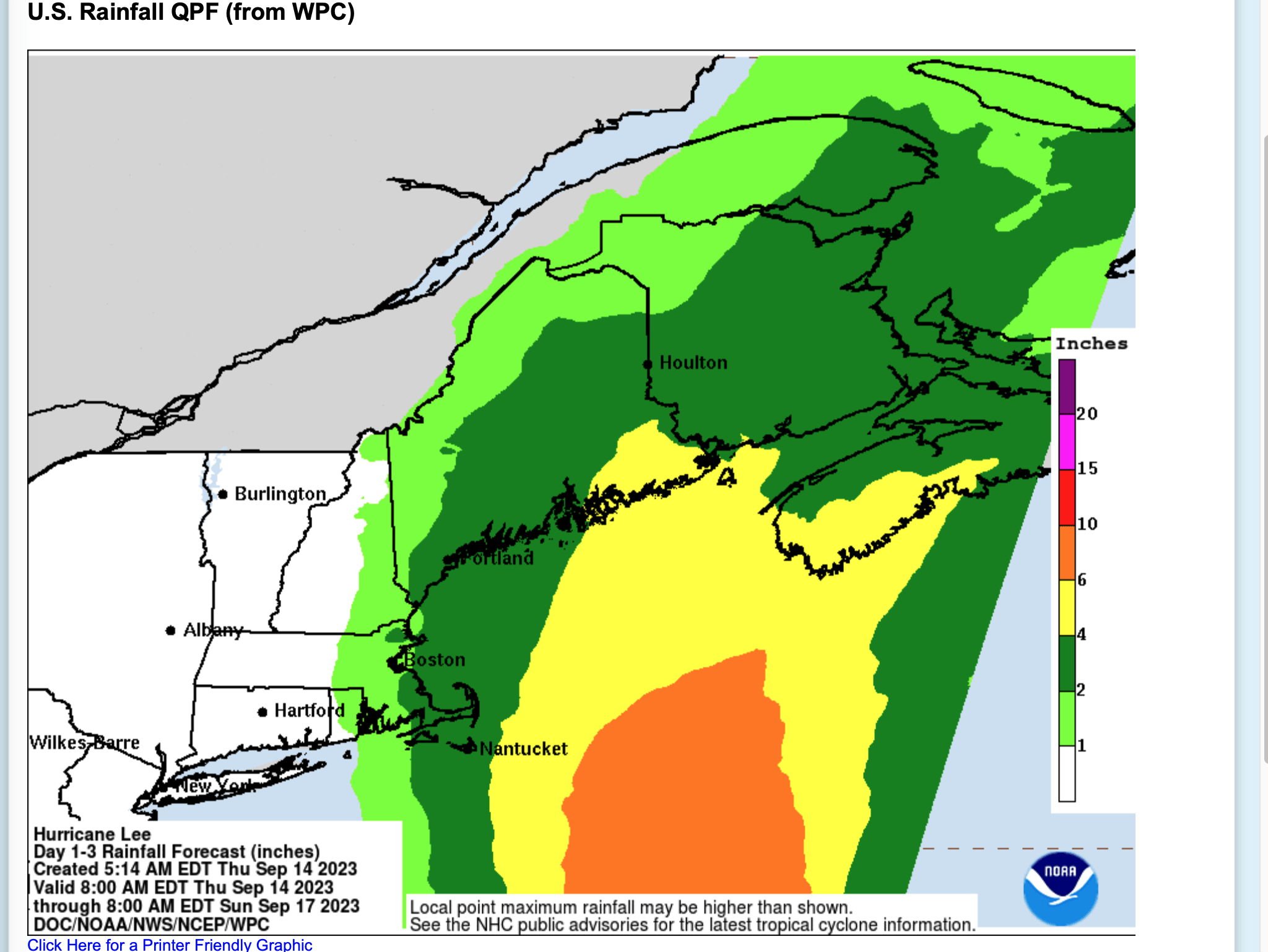
Image for rain potential

Rainfall Prediction

Please note that up to 6-inches of rain is expected over large areas. This can cause life threatening flooding.
What Causes Wind?

Why does the wind blow?

Wind is the effect of hot air needing to expand and cold air is contracting.

High pressure areas flow to low pressure. This means that air in high pressure masses must go to low pressure areas.

As air gets hotter it expands, it becomes lighter, and rises. As the hotter air rises the void it leaves below becomes low pressure. This is what causes wind: Cooler and more dense air rushes in to fill the lower pressure area created when the hot air rose. The higher the difference between high pressure ( cold ) and low pressure ( hot ) results in higher winds.

What causes the air to get hot in the first place?

As far as weather is concerned warm or hot air is caused by the sun heating surfaces on the earth, land, plants and water. The heated surfaces reflect the heat into the atmosphere. Since oceans occupy more surface than anything else, it is the oceans heating by the sun that has a large impact on wind formation. In the same context the warmed ocean surfaces and wind create water vapor which contribute to cloud formation and precipitation. The sun rays strike the earth at different angles depending on the seasons caused by earth wobble and rotation. Direct overhead sun rays will heat much more than glancing rays at low angles. Likewise mountains block sun rays from hitting areas which will cause colder high pressure air pockets. The sun at most can fall upon one half of the earth and heating those surfaces, the other half is dark and cooling.

What Exactly are Dust Devils?

Dusts Devils are a strange yet normal occurrence in the dry sandy deserts. Just mix up a day with rising temperatures and some wind and dirt devils spring to life.

Definition of Dust Devil

A small whirlwind containing sand or dust.

Description of Dust Devils

Dust Devils, sometimes called Dirt Devils, also known as whirlwinds or mini tornadoes, are relatively small, rotating columns of air that pick up dust or debris from the ground, making them visible. They are commonly seen in arid or desert areas, where the conditions for their formation are more favorable. Several factors contribute to the formation of dust devils:

  • Surface Heating:  One of the primary factors that lead to the formation of dust devils is intense surface heating. In desert or arid regions, the sun’s energy can heat the ground quickly, creating temperature differences between the hot ground and the cooler air above.
  • Thermal Instability:  As the ground heats up, the air in contact with it becomes warmer and less dense, causing it to rise. This rising warm air creates a localized area of low pressure at the surface, which in turn induces air from the surroundings to flow in and fill the void.
  • Wind Shear:  Wind shear refers to a change in wind speed and direction with altitude. In areas where there is significant wind shear, the difference in wind speed and direction between the surface and higher altitudes can contribute to the rotation of the rising air column.
  • Surface Roughness:  Uneven or rough terrain can also play a role in the formation of dust devils. Surface irregularities, such as rocks or vegetation, can create areas of differential heating and contribute to the generation of vortices.
  • Coriolis Effect:  While the Coriolis effect is more significant in larger atmospheric systems, it can still have a minor influence on the rotation of dust devils. The Coriolis effect is caused by the Earth’s rotation and can impart a slight spin to the rising air column.

When these factors combine, a rising column of warm, low-pressure air can begin to rotate due to wind shear and other atmospheric dynamics. As the rotating column draws in dust and debris from the ground, it becomes visible as a dust devil. Dust devils are usually small in scale compared to tornadoes and are not typically as destructive, but they can still pose some hazards, especially if they encounter people or vehicles.

Weather vs Climate

Weather is what you see or experience outside at any time on any day.

So, for example, it may be 75° degrees and sunny or it could be 20° degrees with heavy snow. That’s what the weather is. We can discuss long term forecasts of what the weather will be, or what happened last year in this month. It’s all weather, but it is not the same as climate.

How is Weather different than Climate?

Climate is the average of “weather” over an accepted period of time which is normally 30 years or more. When people discuss changing climate they are describing changes from the normal averages.

What causes the Weather?

The two most important influences in weather are the Sun and Earth’s atmosphere. The Sun heats objects on Earth and this heat is absorbed by the atmosphere. The absorption may include water vapor which creates the clouds and can attribute to rain and other types of precipitation. Other factors ( variables ) such as high and low pressure effect the winds and storm systems.

What Exactly are Jet Streams?

A sketch of a couple of jet streams in northern and southern hemispheres

Jet Streams affect our winds down at the surface

As the jet streams move around the globe they rise and fall in altitude. The wind speeds high up in the mountains can be much stronger than in lower surrounding areas. This is due to the jet streams can be low enough to to be blowing through the mountain ranges. With dramatic changes in air pressure the jet streams altitude can change drastically. When wind speeds are above 50-mph the jet stream may only be a mile above the earth surface.

How many jet streams are there?

There are normally 4 jet streams traveling around the earth at the same time, 2 are in the southern hemisphere and 2 in the northern hemisphere. One of them is at latitude of approximately 60-degrees while the second is around the 30-degree latitude. The jet streams shift north or south with the changing seasons.

Why do the jet streams travel from west to east?

Because the Earth is rotating in that direction and surface tension is pulling the wind along in that general direction. The winds ave a tendency to want to move towards the cold poles of the globe.

How fast is the Earth rotating?

At the equator the earth rotates 1000 miles per hour based on 24,000 mile circumference and one rotation per day. On a perfectly still ( no wind ) day the air is also moving along at the same rate as the earth. At 45 degrees latitude, north or south, the earth is spinning in the 707 mph range ( because the distance at that latitude around the globe is shorter ).

How fast is the jet stream traveling?

The jet stream moves along at over 100 mph and even as high as 275 mph. For comparison, F-4 tornado wind speeds are 207 to 260 mph, F-5 are 261 to 318 mph. At the equator the jet stream is moving more slowly and picks up speed with the increase in latitude because as mentioned before, the distance around the globe is shorter, yet, the wind maintains it momentum and must travel faster to cover the same distance as at the equator. Wind speeds also increase with the increase of difference from low to high temperatures. The largest gradient between temperatures is at latitudes of 30-degrees and 60-degrees (north and south ) and therefore the wind speeds will be higher in these areas. Each of these ever changing factors contribute to the wind speed.

Jet Streams do not flow straight around the planet.

The jet streams stay in the boundaries between hot and cold air zones similar to a river staying within it’s banks. The shape of these air rivers is constantly changing as high pressure (cold) and low pressure (hot) cells are actively forming and collapsing. The jet streams general latitude changes as the seasons change, with winter having the strongest winds. The jet streams follow the sun’s latitude changes, ie as the sun moves south after the Summer Equinox, the jet streams will also. As earth enters summer the jet stream is moved farther towards the pole. In winter the jet stream moves closer to the equator.

In summary:

Jet streams are a constant phenomena whether we see them or not. They are constantly racing around the earth trying to find equilibrium between high and low pressure while the earth’s rotation is pulling them along from the west to the east. If the jet stream elevation is low enough we can have very strong winds, even up 100 mph. Jet streams top speed is around 275 mph, that’s in F-5 tornado wind speeds.